Translate

Sunday, April 30, 2017

15 Years in Cook County

Today was the anniversary of my arrival on the Gunflint Trail, fifteen years ago.  Exactly two years before that, I graduated from Concordia-Moorhead.  I had the day off from work today, and decided to celebrate by taking a ten mile hike.  In the course of my journey, I saw Gunflint Lake, Ham Lake, the Cross River, Lonely Lake, and Lookout Point.  I also counted 24 different species of birds.

As a year-long celebration of my decade and a half as a Naturalist, I have started a birding Big Year.  The Big Year is done by birders across the continent (and even the world in rare cases).  Participants pick out a geographical area, and find as many bird species as they can in one year.  Some of the options are: North America, the Continental United States, one state, one county, or your backyard.  I am going to do a ten-mile radius around myself.  If I am already going somewhere, I bird along the way.  A few years ago, I did another Big Year (April 2014 - April 2015).  I was much more of a novice birder at the time, but still was able to see 93 species.  My goal this time is to beat my old record; I'm simply competing against myself.  It would be nice to add several new birds to my life list as well (I already added one today).

Some of the highlights of my 15 years in Cook County are:

  • Learning a lot about history, nature, music, and much more.
  • Over a decade on the Gunflint Trail Volunteer Fire Department.
  • Eight years as a host at WTIP.
  • Learning a dozen musical instruments in the last decade.
  • The Gunflint Trail and Cook County Communities.
  • Visits from friends and family.
  • Great camping trips.
  • All the nice people I have met over the years.
  • Performing in the Radio Waves Music Festival.
  • Great birding.
  • Wonderful pets.
Below are some pictures of today's journey:

Gunflint Lake Overlook

Ham Lake

Black-capped Chickadee (Poecile atricapilla)

Common Mergansers (Mergus merganser) on Lonely Lake

Lookout Point Overlook


Wednesday, April 26, 2017

Signs of Spring Amid a Brief Return to Winter

The spring weather in the borderlands of the United States and Canada is not boring.  A few days ago, it felt like summer.  Today it felt like winter again, complete with freezing rain (which started last night), sleet, and a blanket of snow.  I woke up this morning to the scene below.
Notice the snow on the deck, and the layer of ice on the grill.  Luckily, none of my plants have been put outside yet.  I am also blessed to not have to drive anywhere for a few days, since everything is very slippery.

 The Red Squirrel (Tamiasciurus Hudsonicus) in these pictures climbed inside a feeder, and found food and shelter.  These animals, along with a lot of birds, were eating as much food as they could today to gain extra calories in an effort to stay warm.

The bird migration is continuing.  In the last few days, I have seen White-throated Sparrows, Clay-colored sparrows, Song Sparrows, a Fox Sparrow, Red-winged Blackbirds, Northern Flickers, Common Grackles, Dark-eyed Juncos, Yellow-bellied Sapsuckers, and a flock of American White Pelicans.  The sighting of the pelicans was a thrill because I have only ever seen one of those at a time at Gunflint Lake, and sightings can be years apart.

American White Pelicans (Pelecanus erythrorhynchos)
These birds were very high.  My camera has a 60 X Optical Zoom which was fully utilized.
The Yellow-bellied Sapsucker (Sphyrapicus varius) is one of the two woodpeckers that is only here in the warmer months.  Its' name is a misnomer, as it does not actually suck sap.  It drills a series of sap wells in a grid pattern, licks the sap, and comes back later to eat the bugs who are consuming the sap.  Several other types of wildlife benefit from this food source including, the Red Squirrel (seen above), and the tiny Ruby-throated Hummingbird.

Practicing the Fiddle

 One of my greatest passions in life is playing music.  I can play thirteen different types of instruments, most of which I have learned in the last decade.  When I was in fourth grade, I played the violin in the orchestra, but stopped when I got to the fifth grade.  Last September, I decided to take up the fiddle.  They are the same type of instrument, played with different styles.  The violin/fiddle has the distinction of being one of my earliest, and latest instruments, because after all these years, I had to learn everything again.
 I start my practice session by getting my fiddle out of the case, and tuning it.  The large tuners by the scroll (on the left) are very good, so I usually just use the fine tuners located on the other side of the bridge.  The strings are tuned to G, D, A, and E.  When I first took up the mandolin (which has the same tuning), I made up a mnemonic device to remember the notes: Good Day All Elves.
 Next I get the bow ready.  I tighten the horse hairs just enough to play right, using the screw next to the frog at the base of the bow.

I then check to make sure there is enough rosin on the bow.  The rosin is made in large part out of tree sap, and makes it so the horse hairs grab the instrument stings enough to make a sound.  Without rosin, the bow will not work.  To apply it, I scratch the rosin block with the screw on the bow, and rub the horse hairs over it.

 My warm up consists of a couple of simple tunes that get me off to a good start, and build my confidence.  Often times, it is a medley of Boil 'em Cabbage Down, and Shortnin' Bread.

When warmed up, I will do some drills to help me with my technique.  These drills mainly help with bowing, but can also be beneficial with my left hand as well.  Sometimes, the drills are done early in the session, and sometimes later.  It all depends on how I sound.  I might do my bowing drills if hear squeaking, or have a bow bounce.  Different drills will help solve both problems.

In the course of my practice, I like to do some simple songs to build confidence and work on technique, as well as some more difficult songs to challenge myself and help me feel like I am advancing.  When I first started playing, there was no way I could even attempt a song called The Irish Washerwoman.  Now I can play it with reasonable proficiency, and as I advance, can add even more fiddling techniques.  A big part of fiddling is taking the original tune, and giving it various improvisational flourishes such as slides and drones.

After living on the Gunflint Trail for over fourteen years, I finally got a fast internet connection.  There are a lot of videos online that assist in learning an instrument.  I have found several teachers that I enjoy, and do their lessons from time to time.

I also have several books, and one DVD for learning the fiddle.  The first book I use is Fiddling for Dummies, and I also use the American Fiddle Method book and DVD.  Both those resources have helped me a lot in the last few months.

I try to sight read at least one song per session if time permits.  This has the duel purpose of challenging me, and introducing me to new material.

When the time comes for me to finish my practice, I wipe down the fiddle, and put it in its' case.  The instrument must be wiped down because the sticky rosin dust can build up on the wood and strings over time, making it harder to play, and possibly damaging the finish.
I secure the fiddle in the case, and cover it with a it's blanket.  It almost feels like I'm putting a child or pet to bed.  I put away the cleaning cloth, tuner, and shoulder rest, and then shut the case.

The last thing I do is enter the practice time in my log.  I try to average at least thirty minutes of practice per day over the course of each month.  Some days I practice five minutes, and sometimes it is over an hour.  I'm sure to play a little every day, which is very good for the instrument as well.


Tuesday, April 25, 2017

Gunflint Fire Tower

 Yesterday, I decided to take a hike up to the old Gunflint Fire Tower site.  It is located on a spur of the Kekekabic Trail, which can be accessed from the trail-head on the Gunflint Trail.

From the Gunflint Lake Overlook parking lot, drive towards the end of the Gunflint Trail.  You will pass the South Gunflint Lake Road, North Gunflint Lake Road, and Gunflint Narrows Road on your right.  Then you will pass the Round Lake Road on your left.  A very short distance after the Round Lake Road, you will find the Kekekabic Trail parking lot on your left.  If you come to the Magnetic Rock Trail parking lot on the right, you have gone about 100 yards too far.

According to the Centennial Trail interpretive brochure, the Kekekabic Trail was built in the mid 1930's to give firefighters access to the remote areas of the wilderness.  It stretches 40 miles from the Gunflint Trail to Ely, Minnesota.  The three biggest fires in the last several decades have crossed this path including: the Cavity Lake Fire of 2006, the Ham Lake Fire of 2007, and the Pagami Creek Fire of 2011.


On the way to the tower sight, I saw many wonders of nature, including the Jack Pine cone on the right.  It was so spectacular in the drab colors of early spring that I had to stop and take a picture.  If you want to see pictures of the other two types of pine cones in the area, see my recent Red Pine, Jack Pine, and White Pine article.

The plant on the left is called a Ground Pine, or Princess Pine.  It is a member of the Clubmoss (Lycopodiaceae) Family.  Fossil evidence suggests that this family of plants was around in the Jurassic Period, about 150,000,000 years ago.  At that time, it was about 100 feet tall.  The biggest ones I see now are about 8 inches tall.

These plants are more advanced than moss in that they are a vascular plant.  However, they are less advanced than pines because they reproduce by spores, and they don't have a true root system.  The spores are produced in the thin yellow area on top of the plant, and make a great flash powder for stage explosions.

These next two pictures are of Haircap Mosses (Polytrichum spp.) Moss must have water flow over it to reproduce.  That is one of the reasons they are so short.

The picture on the right is of a combination of mosses and lichens.  This is a good time of year to see all these evergreen plants, because they are covered by snow in the winter, and larger, leafy plants in the summer.

The trail up to the fire tower site is deceivingly long the first time you ascend it.  From the junction with the Kekekabic Trail, it looks like just a short hill to climb to the top.  However, when you get to the top of that hill, there is another hill, and when you get to the top of the next rise, you find the climb continues until you take a turn to the west near the top, and come to the sight of the fire tower.

 The first thing you come upon is the foundation of the old house used by the people who worked in the tower.  It is hard to get a picture of the entire foundation, but walking around it, there were multiple rooms, and 1 or 2 fireplaces.

A few steps beyond the house foundation is the ruins of the cab (top) of the tower.  It is partially crushed, but still surviving.  Image what it was like to stand in this cab when it was raised high in the sky looking for forest fires.

If a fire was spotted, you took a directional reading from the tower, and reported it to headquarters.  They would look on a map, and draw a line from your tower in the direction of the fire.  As other towers called in, they would draw the lines from their towers on the map as well.  The spot where the lines from at least 3 towers intersected was the location of the fire.


 The trail up to this spot was obscured after the windstorm on July 4, 1999, and not opened again until 2005.  At the time of the Alpine Lake Fire, communications personnel from the U.S. Forest Service opened the trail to place communications equipment in one of the highest places around (2064 feet).  

It is worth noting that the lowest point in Minnesota is the shore of Lake Superior (602 feet above sea level), and the highest point is Eagle Mountain (2,301 feet above sea level).  They are both in Cook County.  

 This is one of the few spots in the
area that offers 360 degree views.
These 6 pictures show the 360

degree views from the high spot next to the fallen tower.  Gunflint Lake can be seen in the top left, and bottom right picture.  Imagine what the view must have been like from the top of the tower when it was standing.


The rocks that the tower sits upon are Ely Greenstone.  They are ancient metamorphosed pillow basalt that were formed approximately 2,600,000,000 years ago.  Long ago, magma from a volcano flowed into water and formed the pillow basalt.  Some time later, those rocks were metamorphosed (transformed) by heat and/or pressure into the Ely Greenstone you see today.  This formation contains the oldest rocks in the area, and extends from Ely, Minnesota to the Gunflint Lookout Tower site.


Saturday, April 22, 2017

Red Pine, Jack Pine, and White Pine

Red Pine (Pinus resinosa)
Red Pine Trunk

Red Pine Needles
 Spring is continuing to progress on the Gunflint Trail.  The ice fully departed Gunflint Lake two days ago, the snow is gone, and there is very little ice left on the other lakes and streams of the area.

We still do not have most our green plants yet, although the pine trees are green throughout the year.  There are three types of pines in the area: the Red Pine, Jack Pine, and White Pine.

The Red Pine is our state tree.  It is often called the Norway Pine because it reminded some of the early Norwegian settlers of the Norway Spruce.  It can be identified by the clusters of 2 long needles, thick flaky bark, and a round cone.  The bark is so thick that it can burn for more than an hour in a forest fire, and still survive.


Jack Pine (Pinus banksiana)


The Jack Pine also has clusters of 2 needles, although they are shorter than the Red Pine.  Its' bark is flaky, but not as thick as the Red Pine.  The serotinous cones are tightly sealed until a fire comes along and opens them up (with temperatures of 105 - 200 degrees Fahrenheit.  Jack Pine seeds can handle over 1000 degrees Fahrenheit for a couple of seconds and are one of the first species to come back after a fire.  The tree to the left was born in the Ham Lake Fire of 2007.
Jack Pine Needles
The seroninous (sealed) cones of a Jack Pine can stay on the tree for decades.

The White Pine can be identified by the clusters of 5 needles, and elongated cones.  Remember that there are five needles in a cluster, and 5 letters in the word white.

The White Pine was the mainstay of the timber industry in the area.  It was a preferred tree because it was tall and straight, and floated like a cork.  The trees were sent to the lumber mills by floating them down rivers and across lakes (including Lake Superior).  A very dangerous job at the time was releasing the log jams on the rivers, but it was safer when the trees floated like corks.  When the trees got to the mills, they were used for everything from ship's masts to match sticks.

This whole area was logged at one time.  When Teddy Roosevelt brought about the Superior National Forest in 1909, it was basically described as a bunch of rocks and stumps not good for agriculture or much of anything else.  The forest has come back nicely in the last 108 years.
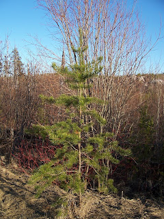
White Pine (Pinus strobus)

White Pine Cone

White Pine Needles
The fresh needles of all 3 of these trees can be used to make a healthy tea that is high in vitamins A and C.  Simply gather some fresh needles (about 1 tablespoon per cup of water), chop them up, and pour boiled water over the top.  Let them steep for 5 - 10 minutes, and enjoy.

The Red Pine and White Pine needle tea tastes pretty similar, and the Jack Pine is slightly different.  I've done blind taste tests with people, and the Jack Pine always wins.

Wednesday, April 19, 2017

Centennial Trail


Yesterday, I hiked the Centennial Trail.  It was created in 2009 in honor of the 100-year anniversary of the Superior National Forest.  This trail celebrates the natural beauty, fire ecology, and history of this beautiful place.  You can start on the Round Lake Road, or the Kekekabic Trailhead.  I chose the latter of the two to begin my journey.

One of the early points on interest on the trail is the nickel test shaft for the Paulsen Mine.  You probably notice that the sign says 1893, the year of the mine's beginning, and end.  It shut down for three main reasons:

  1. It was cheaper to mine iron ore using the open pit method that they were able to do on what is now know as the Iron Range.  The Paulsen Mine used the shaft method.  The town of Hibbing, Minnesota was also founded in 1893.
  2. There was a financial panic in 1893.
  3. The President of the Gunflint Mining Corporation was embezzling money from the Paulsen Mine for the City of Minneapolis, and vice versa.  He ended going to the prison in Stillwater until the governor of Minnesota pardoned him.

The next site I came to was one of the many ponds along the Kekekabic and Centennial Trails.  There was some great wildlife in there, including: two Lesser Scaups (Aythya affinis), two Mallards (Anas platyrhynchos), and one Beaver (Castor canadensis).  The Lesser Scaups are the smaller two ducks.  Can you spot the beaver?

I eventually came to a Beaver dam, and was able to cross over to the Centennial Trail section.  The snow on the trees was from the night before.  Today, we had a combination of sleet and rain.  Most people up here are grateful for the precipitation this time of year because it cuts down our wildfire danger.

The Kekekabic Trail that I started on continues for close to forty miles.  It was originally put in to give firefighters access to the fires deep in the wilderness between Ely, Minnesota and the Gunflint Trail.  It was well placed.  The three biggest fires in Minnesota in the last decade and a half have burned over this trail.  There was the Cavity Lake Fire of 2006, the Ham Lake Fire of 2007, and the Pagami Creek Fire of 2011.  In later blogs, I will talk more about the Ham Lake Fire, since I worked on that fire, and it is the 10 year anniversary of its' ignition on May 5th.


After switching trails, I immediately came across one of the main shafts of the Paulsen Mine.  According to the Pioneers in the Wilderness Book by Willis H. Raff, the main shafts were between 70 and 110 feet deep.  The way they found out the depths was by sending down ropes with weights at the end.  The shafts are almost totally filled with water, and are too dangerous to send in divers.  When the water level is down a little bit, you can see some of the old timbers that were used to support the shaft in 1893.  This shaft was very close to "Gunflint City," the old mining camp.

Continuing down the trail, I came across two Ruffed Grouse (Bonasa umbellus) in different spots.  Both did their best to hide from me.  The picture on the left was of the most photogenic of the two.  It walked back into the brush, and stood very still.  This particular one was very large for its' species.


The trail continued down through some deep valleys, and up over high ridges.  When the mine was active, there was a railroad spanning the valleys, but all the bridges burned in forest fires.  If you look carefully on the horizon, you can see a thin sliver of Gunflint Lake.  The last continental ice sheet to come through here had a melt water stream that formed a dam of glacial till (sediment) that separated this valley from Gunflint Lake.

The train that brought the one load of iron ore out of the Paulsen Mine was called the Port Arthur, Duluth, & Western Railway (P.A.D. & W).  It started out in Port Arthur (now part of Thunder Bay, Ontario), and terminated at the Paulsen Mine.  The train crossed from Canada to the United States over the narrows between Gunflint and Magnetic Lakes.  Due to the loss of the mine, the trail never made it to Duluth.

One of my favorite spots on this trail is a section of the old railroad grade which was cut into a ridge.  The small valley that was formed contains its' own micro-climate, and is always a little colder than the surrounding areas, as is evidenced by the snow in this picture.  Imagine what it was like 124 years ago when I train traveled right over this spot.

I soon came to the Round Lake Road, and hiked next to an old beaver pond, which is actually higher than the road.  There were a couple of ducks in there, which I originally thought were more of the Lesser Scaups that I had seen earlier.  I took several pictures of them, and later, when I put the pictures on my computer, I was delighted to learn that they were actually Ring-necked Ducks (Aythya collaris).  It is definitely worth bringing along a camera when you go birding!

I eventually turned off of the Round Lake Road, and walked a short distance parallel to the Gunflint Trail back to my car.  If you are ever up on the upper Gunflint Trail, it is definitely worth taking this challenging, but rewarding hike.