Translate

Tuesday, May 23, 2017

Fog in Grand Marais

Throughout the day on Sunday, there was fog in Cook County.  I was in Grand Marais doing my Sunday radio shows, and would sometimes see the hills behind the station, and other times be able to see no further than the other side of Highway 61.

At the conclusion of my Classic Country show, I decided to take a walk out toward the main Grand Marais Lighthouse.  I could see the path in front of me, but not much else.   After a short walk, I came to the site of the old Grand Marais Fire Tower, walked around the footings, and pressed on towards the bright flash of light in the fog.

When I was out on the breakwater, I could see the flash of the main lighthouse, plus the other two navigation lights on different parts of the harbor.  The only thing I could see from the town of Grand Marais was a row of blurry lights.  There was also the dim outline of a sailboat anchored nearby.

The fog can be quite beautiful from the shore, but rather dangerous when you are out in Lake Superior.  In 1933, a ship called the George M. Cox was carrying passengers to Port Arthur (now part of Thunder Bay, ON), and the First Mate ignored the Captain's orders to slow down and maintain the current course in the fog.  By the time the Captain found out what had happened, the ship was too close to the Rock of Ages Lighthouse off of Isle Royale.

The Lighthouse Keeper saw the top of the ship from the vantage point of the lantern room high above the fog, and ordered the alarm sounded.  Unfortunately, the Captain, not knowing the exact position of the ship, ordered a turn to the north, right into the Rock of Ages Reef, which had already claimed both the Cumberland, and the Chisolm.

Luckily, no one was killed in the impact, although there were injuries with some of the crew.  The most injured people, and George M. Cox himself were taken to Port Arthur by a smaller ship, but everyone else had to spend the night in the lighthouse.

The Rock of Ages Lighthouse is over 100 feet tall, and can be seen from Minnesota on a clear day, 22 miles away.  However, it was not suited to having over 100 visitors for the night.  People would switch off being inside, and the Keeper"s wife spent the whole night making coffee to warm the people outside.

The next day, the Coast Guard came along and took the survivors onto Isle Royale.  Eventually, the George M. Cox sank into Lake Superior, and is now a popular diving target.  It joined the ranks of over 500 other ships that have wrecked on Lake Superior over the years.

I made it to the lighthouse, rested a minute, and then turned back around.  On the way back, I really noticed the sounds coming out of the fog.  The waves roared in from Superior, and the water gurgled as it passed over the rocks closer to the breakwater.  A beaver was alarmed, and slapped his tail on the water as he dove into the depths.

One sound I missed was the old fog signal that was still working when I first moved to Cook County.  It would sound intermittently day and night until the fog went away.  When the Coast Guard replaced the old Fresnel Lens with an airport beacon, they took out the old fog signal as well.  Now a marine radio is needed to sound the signal.


I made it back to my car, took some pictures of the fog, and drove toward the Gunflint Trail.  The fog thinned as I drove up the hill out of Grand Marais, but remained patchy all the way back to Gunflint Lake.

Thursday, May 11, 2017

Animal Search


This morning, I took some people on an animal search, and there was a lot to see.  We started out at Gunflint Lake, where we saw some Snowshoe Hares, and Blue Jays.  Then we proceeded to the Round Lake Road, and got to see some Ring-necked Ducks, a Painted Turtle, and a Common Merganser.
Painted Turtle (Chrysemys picta)

Common Merganser (Mergus merganser)


Ring-necked Duck (Aythya collaris)


Moose (Alces alces)
 My next stop was on the Moose Pond Landing Road.  It was pretty quiet back there, so we continued toward the end of the Gunflint Trail.  We were just passing the Sag Lake Trail, when I decided to go down there.  I backed up a short distance, and drove down the road.  Much to our delight, there was a young bull Moose in the middle of the road.

Moose (Alces alces)
When Moose are on the road, they have the right of way, so we waited for it to move.  One of the reasons they have the right of way is that they will charge after cars if they get annoyed.  When they start running, they can reach speeds of up to 38 miles per hour.

Luckily, the bulls generally to not charge vehicles outside of the rut (mating) season in October.  However, the cows with the calves will protect their young any time of the year.

A little while after leaving the moose, we arrived at the Trail's End Campground.  Near sites 18 and 19, there is a nice waterfall, which is shown below.

We also saw three Bald Eagles fishing around the rapids (where the Walleye are spawning).  The Bald Eagles do not get their white head until they are 3 - 5 years old.  Two of the birds we saw were immature, and one was mature.  One of each is shown below.


Bald Eagle (Haliaeetus leucocephalus) - Mature

Bald Eagle (Haliaeetus leucocephalus) - Immature

Wednesday, May 10, 2017

Sunset at Honeymoon Bluff


This evening, I took a group of people to Honeymoon Bluff, overlooking Hungry Jack and Bearskin lakes.  The clouds were perfect for the sunset, so I took a lot of pictures.  I've found over the years that the best sunsets need some clouds, and some clear sky.  This was one of the more spectacular sunsets I have witnessed in fifteen years of living on the Gunflint Trail.

The trail head for Honeymoon Bluff is at a parking lot just off of the Clearwater Road, which is accessed from the Gunflint Trail.  You drive past Flour Lake Campground on the right, and shortly after, turn left into the parking lot.

The hike to the top of the bluff is short, but a little steep.  It is pictured on the left.  Most people in at least moderately good shape can make it up.  The overlook is 200 feet over Hungry Jack Lake, with Bearskin Lake off to the side.

This evening, we were the only group up there.  In the summer, there can be lots of people viewing the sunset.  It is worth it to walk all along the wooden fence to view or photograph the sunset from many different angles.

Sunset at Honeymoon Bluff
Hungry Jack Lake is directly under the overlook, and Bearskin Lake is off to the right.
Some of the clouds in this pictures appear to be fire balls.  Ten years ago today, were in the middle of the Ham Lake Fire.

This one looks like a lava flow coming down a volcano.  However, what looks like a mountain with a river a magma is actually a cloud.  The landscape is visible at the bottom of the picture.

This one reminds me of a pool of molten rock.  I was using a 60 X optical zoom for this picture.

I liked this picture because one of the clouds looked like a giant snake, and I am a big fan of snakes.
On the way back to Gunflint Lake, we spotted four American Woodcocks (Scolopax minor), one Red Fox (Vulpes vulpes), and four Black Bears (Ursus americanus).  The first Black Bear looked like a shadow, and when we turned around to look at it again, a sow and her two cubs ran if front of us.

Tuesday, May 9, 2017

Ham Lake Fire - Part 2

By May 9, 2007, we had been fighting the Ham Lake Fire for 4 days.  There had been multiple evacuations performed on the Gunflint Trail.  On May 5th, we evacuated the Round Lake Road.  May 6th, we evacuated the Gunflint Trail from the Round Lake Road to the end.  On May 9th, we evacuated the north side of Gunflint Lake.

May 7th and 8th, we went back to the end of the Gunflint Trail to attempt to save as many structures as possible (although many of them had already gone down).  On one of those days, we had a very calm morning, and about 11:00 PM, flames rose rapidly into the air.  

The Meteorologist on the fire had predicted that we would hit the trigger points at that time, and he was right on.  Trigger points have to do with relative humidity (below 20%), temperature (above 80 Fahrenheit), and wind (above 20 miles per hour).  When those three things occurred, the fire exploded.

Fire activity at the end of the Gunflint Trail increased first.  Don and I were with Engine 583 on the Round Lake Road, when we got called to the end of the Gunflint Trail.  Almost as soon as we got there, we were called back, because fire activity was increasing on the Round Lake Road.  On the way back, Don cut up a tree across the Gunflint Trail, and I put out the fire at the base.  Laura (our EMS Chief) stopped by and put lunches in our truck.

I also remember seeing a lot of fire around Chik-Wauk Lodge.  At the time, it was being restored by the Gunflint Trail Historical Society.  The old roof had been removed, and the new roof was covered with tar paper.  Several fire crews were working on the fire as we passed.  The building did survive the fire, and a few years later, opened as the Chik-Wauk Museum and Nature Center.  If you are ever up near the end of the Gunflint Trail in the summer months, it is definitely worth checking out.

When we got down to the Round Lake Road, flames were heading towards the Round Lake Public Landing.  Forest Service Crews were there planning a back burn.  A back burn is a type of prescribed fire in which you are literally fighting fire with fire.  The area between the firefighters and the fire is burned before the main fire goes through, removing the fuel.  A fire needs three things to exist: oxygen, fuel, and heat.  If one of those three is missing, the fire goes out.  The decision to perform a back burn is only made by the Incident Commander, and is carried out by extremely experienced firefighters.  The forest service lit the fire with drip torches, and it was effective.

By May 9th, the Ham Lake Fire had come to Gunflint Lake.  A decision was made to perform a prescribed burn on the northwest corner of the lake.  Two parallel fires were lit, one by hotshot crews on the ground, and one by a helicopter from the air. The fires burned into each other, creating a line with no fuel.

It was hoped that the prescribed fire would keep the main fire from jumping from peninsula to peninsula on the west side of the lake, and destroying many of the structures around there.  At risk were four resorts, and many residences.

We were put in reserve in the Cross River Gravel Pit in case things didn't go as planned.  For the first time in the Ham Lake Fire, I had a chance to take some pictures.
de Havilland DHC - 2 Beaver
These aircraft  can be used for initial attack, but they only carry 100 gallons
of water, so they are used for reconnaissance when a fire becomes large.
They also have the capability to act as an air ambulance in the wilderness.

Smoke plume from the gravel pit.

Sikorsky S - 64 Skycrane
There is a strong pump at the end of the hose, which when dipped in a water source, can full up the tanks in about 2 minutes.

Sikorsky S 64 Skycrane releasing  water.

Sikorsky S - 61 Fire King dropping water.

Engine 583 with fire in the background.

Smoke plume from prescribed burn.

Sikorsky S - 61 with bucket.
Several types of helicopters were equipped with these buckets.  The pilot would hover, placing the bucket in a water source.  It would tip over, and submerge, at which time, the pilot would pull up, and bring the water back to the fire.  When in position, the bottom of the bucket would be released, and the water dumped on the fire.

Two Sikorsky  S - 61 helicopters, with different methods of carrying water.

I climbed up a hill at the back of the gravel pit to get a perspective of the size of the smoke plume.

Sikorsky S - 64 Skycrane dropping water.
Sikorsky S - 64 Skycrane dousing the flames.
 The prescribed burn was successful, and many buildings on Gunflint Lake were saved.  A day later, the Ham Lake Fire ran down the north shore of Gunflint Lake, taking 14 structures, and causing the evacuation of the remaining residents on the south shore of Gunflint Lake.  Amazingly enough, a crown fire (in the treetops) can jump more than a mile (the average width of Gunflint Lake) by shooting burning embers (often birch bark or lichens) up on the updraft of the fire.  The wind then takes the burning embers ahead, and starts another fire.  Due to this leapfrogging nature of crown fires, the south shore was in major danger.

That night, I stayed at my home on the South Gunflint Lake Road.  The glow of the fire was visible all along the north shore, but calmed down enough for me to be in that location.  However, I did sleep with the fire truck in front of my house.

The following day, the fire hopped over the east end of Gunflint Lake, and formed a southbound arm which again crossed the Gunflint Trail.  I was on an engine crew to the east (Grand Marais) side of the arm.  When the flames had calmed down, we drove back up the Gunflint Trail.  It was the second time during the fire that I went down a road with the glow of flames on both sides.  I spent that night at Golden Eagle Lodge with a bunch of other firefighters from around the county.

Soon after that, I was assigned to sections of road around Seagull Lake on engine 583.  I'll talk more about that in the Ham Lake Fire - Part 3 article.


Friday, May 5, 2017

Ham Lake Fire - Part 1

Today is the tenth anniversary of the start of the Ham Lake Fire.  I plan to write a series of articles about it over the next two and a half weeks.  This article will focus on what happened in the first few days of the fire.

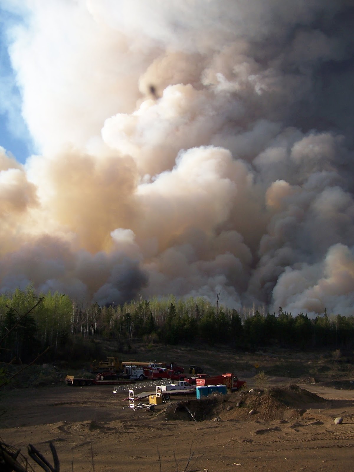
I spotted the plume of smoke at about 11:30 AM on May 5, 2007.  It was visible from the Gunflint Horse Stables several miles away from the ignition point at Ham Lake.  The day was warm, dry, and very windy.  I decided to forget about my horse ride, and traveled over to the Cross River Landing on the Round Lake Road, where there was already heavy smoke and ashes falling from the sky.  I called it in on the fire radio to Cook County Dispatch (which at least one person had already done).

Shortly after getting dropped off at Gunflint by the person who had driven me to the landing, the Gunflint Trial Volunteer Fire Department was paged out.  I responded in Engine 573 to the junction of the Round Lake Road and the Gunflint Trail.  When I got there, Mike Prom, our Assistant Chief, had taken Incident Command.  He and Don had responded in Engine 583.  The residents of the Round Lake Road were being quickly evacuated, and our leaders worked out a plan.
GTVFD Engine 2526 (formerly 573)

Soon, engines from the Minnesota Department of Natural Resources, and the United States Forest Service, along with our Engine 563 arrived at the staging point as well.  Several aircraft were also working the fire by that time.  One of the Forest Service firefighters assumed incident command.

The first priority in any fire is human lives.  There were two portages from Ham Lake to get back to the Cross River Landing, both of which were engulfed in flames.  The only way to get in there by land was an obscure path that I knew of, that was not on any maps.  Armed with that knowledge, I was attached to a two man Forest Service crew to bring them into Ham Lake, and evacuate the occupants.
Ham Lake Ski Trail
This was taken on April 30, 2017.  I did not have time to take pictures during the Ham Lake Fire until April 9, 2017, four days into the incident.

This is entrance to the still unnamed trail off of the ski trail.

This is going down the unnamed trail.  It was bone dry when the Ham Lake Fire started.

Here the trail narrows again about 100 yards from Ham Lake.

This is the trail right before Ham Lake.  It was slippery a few days ago, but dry on May 5, 2007.

We drove up the Ham Lake Ski Trail, and hiked in the back trail from there.  When we arrived at Ham Lake, there were 1 foot tall waves, and strong winds.  Ham Lake is a small lake, and rarely has waves of that size.

This picture of Ham Lake was taken on April 30, 2017 from the furthest campsite from the site of the blaze.  On May 5, 2007, we were able to see the fire when looking in this direction.
Aircraft were flying low overhead trying to knock down the fire at the head.  I remember specifically CL-215's dropping water, and a P-3 Orion dropping red powdered fire retardant.  There were probably Beaver aircraft up there as well, but by that time (since they can only drop 100 gallon of water), they would have been used as spotter aircraft.

The first two campsites we came to did not have any occupants, but the peninsula site did have a Forest Service crew on it.  Ironically, they were up here for a clean air conference.  The fire was going in the opposite direction, so they decided to stay put until they found a way out.

I paddled with one of the firefighters up to the camp site at the heal of the fire.  There were several burning spots on the campsite, and the fire had hopped over the Cross River, which exits the lake at that spot.  The fire quickly spread downwind of that point.  However, the only spot on Ham Lake to burn was that campsite and a tiny bit of the shore across the river.  Fires are named after their point of origin, but not necessarily their area of worst damage.

We searched the other bays in the lake, and did not find the person who started the fire.  The Forest Service crew on the peninsula campsite had seen him close enough for a positive identification, but he was nowhere to be found.  He made his own way out later that day.

The person who started the fire had been coming to that site for many years.  He liked paddling out there as soon as the ice went out.  From everything I have read, and everything I have heard from the people who knew him, he did NOT start this fire on purpose.

After closing the site where the fire started, we returned to the peninsula site, and helped get everyone (and their equipment) out.  We were met on the King's Road by one of the outfitters vehicles, and completed the evacuation.

Soon, I was back with the rest of the Gunflint Trail VFD at Tuscarora Lodge.  We were helping to put up sprinklers, and putting out fires on the shores.  I remember seeing and hearing the fir trees torching very close to us.  There was a whoosh and a cracking sound, and a whole 60 foot tall tree would be engulfed in 3 - 5 seconds.  Aircraft came in and dumped water on them.  Otherwise, we would have had to retreat.

That night, most of the firefighters went home to get some rest.  They chose the youngest person on the department, and the freshest person (Dan F.) to take the night watch of the Round Lake Road.  I was the youngest at the time.  We were told to watch over the Round Lake Road and call if any more structures were in danger.

We spent the night patrolling the area with Engine 573, and putting out fires as we found them.  By morning, we could see the fire had moved well beyond the Round Lake Road, and was headed for the Seagull Lake area.  We were relieved at 6:30 AM, and I went home to get some rest.


May 6, 2007:

Before going to sleep, I had a bowl of oatmeal, which is all I had the day before as well.  It was a good thing I ate at that time, because at approximately 10:30 AM, we got paged out again to evacuate the end of the Gunflint Trail.  I had gotten only about 3 1/2 hours of sleep, and did not have a chance to eat again before returning to duty.  Later that day, I asked one of the other members of the GTVFD (Sue) if I could buy some food from her, and she just said I could just have some.  Shortly after that, a truck arrived with snacks.

I learned some lessons about wildfires and food in those first days of the fire.  Always have some flavoring for the oatmeal (it was plain those days), and have some food with my wildland gear.  At the beginning of each wildfire season, I put some granola bars in with my gear pack, because it may take a day or two to get the food arranged for the crews.  By the way, it took a few months before I could eat oatmeal again.

I spent most of the second day evacuating the residents.  We traveled to the ends of the roads off of the Gunflint Trail, and worked our way back, stopping at every residence.  If people were there, we gave them the evacuation procedures.  Otherwise, we left a note.  The residents who were cut off from Grand Marais by the fire were told to gather at Sag Landing, which is where I was stationed next along with Nace, who was another member of the department.

Boats were in the water in case the fire overcame the parking lot.  We had a plan to rendezvous at the Chippewa Inn in Ontario if our position was overtaken.  Luckily, that did not happen.

From time to time, we would get word to send the residents down the trail (towards Grand Marais).  We would let about five cars go, and get word from someone else that the fire was hopping back and forth over the Gunflint Trail again.  This happened several times before the residents were gone.

Once all the residents were out of there, I was put on lookout duty.  One of the main acronyms we learn as wildland firefighters is L.C.E.S., which stands for Lookouts, Communications, Escape Routes, and Safety Zones.  Someone is always supposed to be back from the fire a little ways, watching the backs of the people on the front lines.  We were making sure the crews up in the Trial's End Campground did not get cut off from their safety zones.

Once they had left the campground, we were able to retreat.  I was in one of the last two cars to leave the end of the Gunflint Trail that night.  Mike Prom was driving, and he had a yowling cat in the back.  It was after dark, and the glow of the Ham Lake Fire was eerily on both sides of the road as we headed down the trail.

May 7 - 8, 2007
The next couple of days (and for most of the rest of the incident), we were on structure protection.  We arrived at the overall briefing at 6:30 AM, and had our division or group briefings shortly after.  I was in Engine 583 with Don those days.  We would be assigned a section of a road, and told to protect the structures.

This meant walking around the properties, and putting out any fires that we came across.  We also checked on sprinkler systems, and marked the tree snags with "Deadly Tree" tape.  A sawyer would come along later, and remove them.

We flagged off the areas around the destroyed structures.  The outlines of the structures were still visible.  They looked like grey lines with neat piles of nails.  The chimneys were still standing, and we gave them a wide berth.  When we found a destroyed structure, we documented the position, and turned it in at the end of the day.

GTVFD Engine 2536 (Formerly 583)
I was attached to this truck for most of the Ham Lake Fire
We were working so hard those days that we would regularly go through a whole flat of water bottles for a two person crew.  I would finish one, and immediately drink another.  By that time,we also had good sack lunches, and dinners as well.

The fire went up through the end of the Gunflint Trail, into Ontario, and then came back to Gunflint Lake.  I remember hearing about possibly naming the incident the "Compass Fire", because the wind blew in every direction of the compass.  As the fire approached Gunflint Lake on May 9, 2007, a back burn was planned, which I will go into in the "Ham Lake Fire - Part 2."

Thursday, May 4, 2017

Anniversaries and Birding Blog

This week I have a lot of anniversaries of big events in my life.  April 30, 2002 is when I came up to live on the Gunflint Trail, and exactly 2 years earlier, graduated from Concordia College - Moorhead.  May 4, 2015 is when I landed in Ireland.  The Ham Lake Fire started on May 5, 2007.  On May 6, 1997, I headed out to New York City with the Concordia Choirs to sing in Carnegie Hall.  A lot of life changing events seem to happen to me around the beginning of May!
Kylemore Abbey, Connemara Peninsula, County Galway, Ireland
Mom and me at the Cliffs of Moher, County Clare, Ireland
These are the tallest cliffs in Europe, and a great birding spot as well!

Today, I worked as a Naturalist in the morning and afternoon, and just completed my Thirsty Boots show at the radio station.  In my show, I played music about fire in commemoration of the Ham Lake Fire anniversary tomorrow.  Then I played Celtic Music in commemoration of the trip with my Mom to Ireland.  There was fiddle music in there, since I am learning the fiddle.  I even played some songs about birds.

I am continuing to look for bird species for my Big Year.  I'm up to 42 species in the last 5 days.  If you want to follow my birding Big Year, I created a separate blog.  The address is https://sillimanbirding.blogspot.com.  Every few days, I will update my birding list, and show you pictures of some of the birds I have spotted.