Translate

Monday, December 31, 2018

Wild West Trip - Minnesota and South Dakota

Red Fox (Vulpes vulpes)
 My wild west trip started early on May 6th.  When I arrived at my car, their was a fox waiting for me.  It watched me from about 10-feet from the car, and jumped back when I started the engine and backed out.

My first day's drive ended in the Twin Cities after a 300-mile drive.  I spent a nice night with my parents before heading off early the next morning for the Badlands National Park.


Storm over the Prairies Near Wall, S.D.
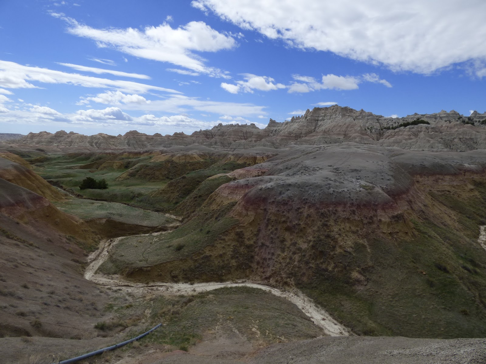
 Most of South Dakota is quite flat, which makes it easier to see the storms coming.  Near Wall, South Dakota, I saw several amazing storms crossing the prairie.  After a brief stop at the famous Wall Drug Store, I entered the Badlands National Park, and found my way to the Sage Creek Wilderness Campground.

Since there were storms visible all around the campground, I decided to spend that night inside my car.  When the storms blew through in the middle of the night, I was glad I had made that decision.


Wall Drug Store, S.D.
Badlands National Park, S.D.
Then next morning, I was awoken by the serenade of the western meadowlark.  I got out of my car to enjoy the beautiful music, identify the bird, and get some pictures before climbing back into the car to get a little more sleep. The campground was beautiful around sunrise.
Western Meadowlark at the Sage Creek Wilderness Campground, Badlands National Park, S.D.

Sage Creek Wilderness, Badlands National Park, S.D. at Sunrise
When I got up again, people were moving around the campground.  Much to my delight, prairie dogs were within the campground, and bison were roaming on the outskirts.  I enjoyed a quick breakfast and went exploring on foot to see the fascinating geology and wildlife of that beautiful Sage Creek Wilderness campground.

After breaking camp, I took the road tour of the Badlands National Park.  The geological formations, and wildlife were spectacular.  Some of the wildlife highlights were the prairie dogs, bison, pronghorn, and many great birds.
Prairie Dog

Prairie Dogs
Sage Creek Wilderness, Badlands National Park, S.D.

Bison in the Badlands National Park, S.D.

Pronghorn in Badlands National Park, S.D.

Badlands National Park, S.D.

Badlands National Park, S.D.

Badlands National Park, S.D.

Mt. Rushmore, S.D.
After touring the Badlands National Park for several hours, I drove to Mt. Rushmore.  It was fun to see these famous carvings as well as all the state and territorial flags, and read about the history in their visitor's center.  On the way out, I stopped at a wayside to get a side view of the presidents, and also caught a distant glimpse of the Crazy Horse Memorial.
Mt. Rushmore, S.D.
Mt. Rushmore, S.D.


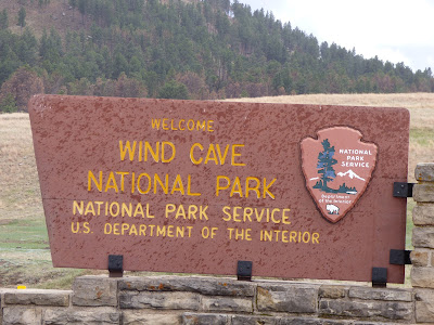
Wind Cave National Park, S.D.
The next leg of my journey brought me through Custer State Park to the Wind Cave National Park in time to get on the last cave tour of the day. Wind Cave is the fifth biggest cave in the world, and the third biggest cave in the United States.  It is famous for the winds that come out of the natural entrance, the sheer size, and the world's largest collection of boxwork formations.  I highly recommend a tour through this unique cave system.

Please note that they are taking good steps to prevent the spread of white-nose syndrome in bats, you cannot enter the cave with any clothing that has been in another cave outside the Black Hills in the last five years.  I found this to be true in other National Parks and Monuments out west as well.
Boxwork Formations in the Wind Cave, S.D.

Wind Cave, S.D.

Wind Cave, S.D.

Custer State Park, S.D.
After the tour, I took a quick drive around the very scenic Custer State Park, and spent the night in the Elk Mountain Campground of the Wind Cave National Park.
Bison with Calves in Custer State Park, S.D.

Bison Herd in Custer State Park, S.D.

Friday, December 7, 2018

Thin Ice

Last night, we had temperatures at Gunflint Lake down to - 11 degrees Fahrenheit.  It was a calm night, and Gunflint Lake was frozen by morning.  If we are lucky, it will be safe for travel close to the end of December.

Gunflint Lake is 275 feet deep at the deepest hole.  With that volume of water, it takes a long time to change temperature enough to freeze.  Every year, Gunflint Lake ices over after the lakes in Southern Minnesota (including the Twin Cities).  Remember to check on the ice before going on it.

The Minnesota Department of Natural Resources recommends at least 4 inches of new, clear ice for walking, 5 - 7 inches for snowmobiling, 8 - 12 inches for a small car, and 12 - 15 inches for a medium truck.  Double those amounts for white ice.  Remember, ice is never 100% safe!  For more information, see the Minnesota Department of Natural Resources Website.

Many people are killed every year by traveling on unsafe ice.  Over the years, many more people have been killed trying to rescue the people stupid enough to go out on thin ice.  Remember, that travel on thin ice not only risks your own life, but the lives of rescuers as well.

When the ice is thick enough to travel, I recommend bringing some ice picks. They can be put on a rope and easily carried with you.  I've tested these (when I was wearing an ice rescue suit during fire training), and they work well.

If you drive on the ice (which I don't), leave your windows down while in the car.  Your best chance of survival is to get out of the car before it sinks.  When a car goes down, it will go engine first, and most likely flip over on the bottom of the lake.  Unless you have something to break the window, you have to wait for the car to fill with water before attempting to swim through water colder than you can image to the surface, and hope you can find the hole you came through and pull yourself out onto the ice.  I personally recommend driving only on land.

Another thing to remember, just because someone else has gone on the ice does not mean you should go on the ice.  We are humans, not lemmings.  Pay attention to the "Thin Ice" signs, talk to people who live on the lake, and test the ice before walking on it.

Stay safe out there!


Tuesday, August 21, 2018

The Passing of Ronny Setniker - A Polka Legend

When I was hosting the Polka Time show on WTIP last Sunday, I got some sad news.  Ronny Setniker had passed away.  Even before I got the call, I had been planning on playing some of his music in the next set, as I had in many shows before.

I confirmed the information online at https://www.wdio.com/news/ron-setniker-polka-music-accordion-range/5035057/.  There was a nice tribute to him on the newscast.

There is one thing that set Ronny Setniker apart from the other musicians I play on my my shows.  Every few months, he would call me and thank me for playing his music, and that of his family.  In my 9-years on the air, he was the only musician not in the studio with me to do so.  I always enjoyed our conversations, and will miss hearing from him.

One time, he called me up and said that he had been honored to have a Polka written in his honor by another musician named Bud Hyrczyk.  He said he was very humbled by the honor, and asked for my address, so he could send me the CD.  It was called the Setniker Polka, and I ended my show on Sunday with that song.

According to the news story listed above, and the biography on Ronny's website, he was a Grammy nominee in 1998 and 2007.  On June 24th, 1999, he was inducted into the Ironwood Polka Hall of Fame.  He was also a Vietnam Veteran, and a retired steelworker.

According to his website, his most recent album was called Tradition.  He did the album with his daughters Susan and Shelby, with whom he passed on his love on Polka music.

Ronny had been playing 4-hour shows just weeks before he died.  He passed away on National Polka Day, August 9th, 2018, at age 79.

Sunday, August 5, 2018

Blueberry Picking on the Gunflint Trail

A week ago, I took a day canoe trip on the Pine and Granite Rivers with one of my coworkers.  Those rivers mark the border between the United States of America and Canada.  To find them on a map of Minnesota, look at Cook County (the tip of the Arrowhead over Lake Superior).  Follow the international border from Lake Superior until it takes a sharp turn to the north.  You have then found the Pine and Granite Rivers.  The Pine River is south of Granite Lake, and the Granite River flows north from Granite Lake.

The two rivers are in a large granite formation (Saganaga Batholith).  Both rivers were burned during the Ham Lake Fire of 2007.  The combination of those two factors makes for some great blueberry picking.

We started out the day by paddling far down the river to the Swamp Portage.  Along the way, we stopped to eat blueberries, Saskatoon berries, and raspberries.  Our plan was to pick some berries to save on the way back.

The swamp portage was beautiful.  We had little rain for the previous few weeks, so it was not as wet as I remembered it.  However, there was still some great amphibian life present.
Northern Leopard Frog (Lithobates pipiens)

Swamp Portage

American Toad (Anaxyrus americanus)

Granite River from the Swamp Portage
After the Swamp Portage, we turned around and headed south.  There were blueberries all along the river, and we stopped a few miles to the south to pick our fill.  We also ate out lunches, as well as a lot of Saskatoon berries, raspberries, and pin cherries.

Blueberries (Vaccinium corymbusum)

Saskatoon Berries (Amelanchier alnifolia)

Bucket of Blueberries - I added a few more inches of berries after this picture was taken.
When we were finishing picking our berries, several thunderstorms came into the area.  We had to wait over an hour for the storm to pass, and then we were able to paddle home.

Thunderstorm on the Pine River
Tips of Picking Blueberries on the Gunflint Trail:
  1. Look for the best blueberry patches in the burned areas on the granite hillsides of the upper Gunflint Trail.
  2. Bring a gallon ice cream pail for carrying your berries.  It is a wide top, and carries a lot of berries.
  3. Ask the locals for good picking spots.
  4. Keep your car or boat is sight, as it is easy to get turned around in the burn areas.
  5. Be a clean picker.  Pick only the ripe berries.  It is better to sort the berries in the field instead of when you want to eat them.  Dirty pickers (who rip everything off the berry bush) are very wasteful and inefficient.
  6. Freeze your berries directly in the ice cream bucket.  There is no need to wash them until you are ready to eat them.

Monday, April 23, 2018

Spring Storm on Lake Superior

Last week, much of the country was impacted by a huge storm.  On the radar, it went from at least the Canadian border to Cuba.  The top of the storm was spread out like the cap of a mushroom across the Great Lakes.  Waves were reported on Lake Superior to the National Weather Service as being at least 15-feet tall by one of the ships struggling far from shore.  Here are a series of pictures and one video of the storm:
This shrub had one of the most amazing icicle formations I have ever seen.

Most people wouldn't even notice this shrub on a normal day.

The parking lot was covered in glare ice.


The seawall I was facing is 8 - 10 feet tall and the waves in the next few photos were a long way above it.


This is a picture of Artist Point.  Notice that everything is covered with ice.
 

The reason I was down in Grand Marais during that storm was to do my Sunday radio shows.  I announced the weather every half-hour instead of the usual hourly frequency.  Every time I refreshed the page from the National Weather Service, the outlook more dire.  When I took my dinner break between shows, my car fishtailed a little when I turned onto highway 61, and I felt the anti-lock breaks come on when I stopped.  Luckily, some great friends let me stay at their house in Grand Marais that night, so I did not have to risk the drive home.

The next morning, I took some pictures of the aftermath of the storm in Grand Marais.  There were still some waves, but they were small enough for me to get close to the lake, and see the ice formations.

These ice-covered railings are by the East Bay Suites.

You can really see how high the waves splashed up on the southwest breakwater lighthouse.

This picture and the next are of the same shrub.  The icicles were absolutely amazing.  On Thursday, I came back to Grand Marais, and found that many of the branches of this magnificent icy shrub had shattered under the extra weight.

It is rare to seen neighboring icicles going in different directions.

This breakwater was covered with glare ice. 
Three days later, it was bare again.

The storm made Artist Point look like something out of Dr. Zhivago.

The ice covering made this stump and pine cone look like they were petrified.

This ship is passing the edge of Artist Point.  We usually see ships from Grand Marais in the early and late shipping season, but not in the middle.
When I came back to attend the Artist Guild meeting  at the Grand Marais Public Library on Thursday, most of the ice formations had melted.  It has been sunny and warm ever since.  Winter may have given us one more show, but spring is definitely on the way.